TheWire
5/12/2009 00:01 | Works awesome except in Step 9, I created a list with columns Address, City, and State. If I enter "Address,City,State" for the Address textbox, I get a "Server Error in '/' Application" error saying "Column 'Address' does not belong to table." If I enter just "City,State" then it works fine. Any ideas/suggestions?
Thanks! |
|
Juerg
5/12/2009 10:31 | Please remove any blank characters in the "Address" field and also check if you did not make any typo.
We have now updated the web part to automatically trim the values contained in the "Address" field. |
|
TheWire
5/12/2009 15:22 | Thanks for an awesome webpart! I just had to remove the connection between my webparts and re-create it. Then it the address worked just fine. Thanks again! |
|
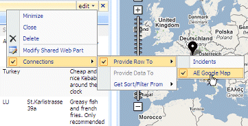
ozbroomy
5/18/2009 07:55 | How do I make the map and list appear side-by-side as shown in your "Connected Web Part (non-interactive mode)" sample |
|
Juerg
5/18/2009 12:02 | Just place the 2 web parts on a Sharepoint page that allows to add web parts when in Edit mode.
You find your List web part in the �Lists and Libraries� section in the �Add Web Parts� dialog box. |
|
spva
5/19/2009 19:24 | I've put the .dll file in the C:\Inetpub\wwwroot\bin directory and added the code into my web.config.
But when I try to add the web part, I still get the error "AE Google Map: A Web Part or Web Form Control on this Page cannot be displayed or imported. The type is not registered as safe."
Any suggestion as to what I am missing? Thanks. |
|
ozbroomy
5/20/2009 10:22 | Thanks Juerg,
I found this suggestion elsewhere, when I ran into an issue adding your webpart dll's into the GAC and other's may find it useful.
I use windows server 2008 and .net 2.0 and couldn't drag and drop files into the GAC (c:\windows\assembly). It said I didn't have permissions. This is what I did to get around it.
- Run Command Line as Administrator (right click on link and run as administrator - new in windows server 2008).
- Change directory to "c:\program files\Microsoft Visual Studio 8\SDK\v2.0\Bin" to run the GacUtil command. Download the .NET 2.0 SDK if you don't have this directory.
- Run the Gacutil command
GacUtil -i "path to your webpart dll"
You should see a message saying it successfully added it to the GAC and you can then add the SafeControl command to your Web.Config file and upload the webpart to your site.
I love your webparts - I can see there is lots of work there and I really appreciate you putting these out there for free. |
|
Juerg
5/20/2009 11:18 | spva,
You probably either forgot to add the �SafeControl� entry to the Web.Config file (See step 3 in the installation instructions) or you applied it to the wrong Web.Config file.
The correct location of this file on your Sharepoint server is most probably at
C:\Inetpub\wwwroot\wss\VirtualDirectories\80 |
|
spva
5/21/2009 21:33 | Thanks, Juerg. I moved the dll file to and updated the web.config in the C:\Inetpub\wwwroot\wss\VirtualDirectories\80 directory and it works. The stand-alone and the interactive map work great!
Similar to TheWire, I also created a list with Address, City, State, and Zip and connect the two webparts as shown in Step 8 and 9. However, I get the follow errors:
Column 'Address' does not belong to table!
Column 'City' does not belong to table!
Column 'State' does not belong to table!
Column 'ZIP' does not belong to table!
Any thoughts? Thanks! |
|
ozbroomy
5/26/2009 08:53 | When my page loads, nothing is selected on the map list, so no map displays. Is there a way to set a default so the map will show when the page loads? |
|
sharepointUser
5/28/2009 11:11 | I have a problem with this webPart :
" Error accessing the Google Geocoding service:The remote server returned an error: (404) Not Found."
I think is due to the proxy. Is there a solution for sharepoint users who can use a proxy server for internet ?
Thanks for your reply ! |
|
Juerg
6/4/2009 10:51 | can you check the �defaultProxy� setting in your web.config file ? By default it looks like:
<system.net>
<defaultProxy>
<proxy autoDetect="true" />
</defaultProxy>
</system.net>
You might have to add your specific proxy information as follows:
<system.net>
<defaultProxy>
<proxy usesystemdefault=�false� proxyaddress=�http://xxx:yyyy/� bypassonlocal=�true� />
</defaultProxy>
</system.net>
where �xxx� is your proxy server IP (ISA) and �yyyy� is the port of the proxy. |
|
Marian
6/12/2009 13:21 | Great web part, works just great and its so easy. I only have one problem, maybe its a problem of more webparts, dont know yet. When i deploy this to English environment it works. Then I have a language pack installed, and on the site created in the other language pack it just dont show. It gives shows me :
Latitude or Longitude is not a valid number! - that gives me right away over the web part and then when i input the adress or connect to right list it shows me:
Input string was not in a correct format.
On the same site collection i create english based site and then it works nicely, so there is no mistake in GAC or web config... It seems its a server language pack thing...
Is that possible to get fixed somehow? Anyway the Clock web part works just fine in my Slovak language pack environment...
Thank you for any answer! |
|
Jan Willem
6/15/2009 15:33 | Great work - I could make the webpart work with addresses without any problem. When I tried to use the longitude/latitude, I had problems to make it work. I created a custom list with Longitude (Number) and Latitude (Number). The webpart worked for the longitude but seems to has problems with the latitude - if I change the latitude to another value then 0 the map doesn't show.
I saw a typo in your documentation on the site (latidude - latitude) perhaps there is the same typo in the source code. |
|
Juerg
6/15/2009 16:25 | Jan,
what are the values you are trying to use for the latitude and longitude ? Also, what�s your Sharepoint Server�s Locale ?
We are aware of a problem with non-English Sharepoint setups, specifically locales which do not use �.� as the decimal point. |
|
Juerg
6/16/2009 17:35 | Marian and Jan,
we now have taken care of the problem with non-English enivronments. The problem occured for locales having a decimal separator other than "."
Please re-download the ZIP file, extract the DLL and replace the old one. Please then also do an IIS Reset. |
|
Cat
6/18/2009 05:57 | Great web part, works just great and its so easy. I only have one problem. I created a list with columns Title, Description, Address and City, same as your example. If I enter "Address,City" for the Address textbox, no any map will be displayed.
Any suggestion on this? Is there any standard when I input the data in the specified list? Thank you. |
|
Juerg
6/18/2009 11:17 | Cat,
did you create the Web Part connection between the List and the Map Web Part as described in the instructions above ? |
|
Cat
6/19/2009 04:47 | Juerg Amrein, yes, I have created the Web Part connection between the List and the Map Web Part. |
|
Cat
6/19/2009 04:49 | I follow your above example (e.g. New York 2175 Broadway) for testing this webpart, but no map will be displayed. |
|
Juerg
6/19/2009 10:37 | Cat, did you click on the radio button in the first column of the Sharepoint list to select a specific list entry ? |
|
Cat
6/19/2009 11:25 | Sure, I clicked. |
|
Marian
6/22/2009 13:16 | Thank you Juerg, it works great! |
|
Cat
6/25/2009 10:21 | Hi Juerg, any sugeestion on my problem? Please suggest |
|
Juerg
6/25/2009 11:28 | Cat,
can you indicate if you checked "Interactive Mode" and/or have entered a Google API key or if you rather use "static" mode (no Google API key). If possible, can you also send us the HTML source code for that page (by selecting "View/Source" in your browser) to have us inspect the generated code ? |
|
Cat
6/25/2009 11:41 | Juery, Thanks your your prompt reply.
For the interactive mode (with Google API key), the world map will be displayed.
For the static mode, If I created a list which is contained longtitude and latitudem columns, the specified map can be displayed. But, If I created a list which is contain City and Address columns, no map will be displayed.
I have sent the HTML code (called "cat_html.html") to your support email: [email protected]. Thank you for your help. |
|
Joseph Wright
6/30/2009 21:42 | I've connected the Google Map Webpart to the Connections > Get Row from Provider > [data] list Data List Contains Address (text) City (text) When I select a data row via radio button, the map webpart issues the following error : Column 'Address' does not belong to table!
I validated the [column name] 'address' was set in the Address Field (via Modified Webpart) So I'm at a loss to understand why the Map Webpart isn't taking the data list values. Do the column(s) need to be a specific data type other than Text Type? Thanx - J |
|
David
7/1/2009 02:07 | Hi Juerg, I use Latitude and Longitude. If I choose not use Interactive Map, the position displays in the map. If I choose Interactive Map, the map shows, but the position doesn't display. Any idea? Thanks |
|
Juerg
7/1/2009 14:55 | Joseph,
we now have added more detailed error reporting to the Map web part plus also now access the list columns by Index rather than by Name.
Can you please re-download the ZIP file, extract and replace the DLL ? If you deployed to the GAC, please also do an IIS reset. |
|
Juerg
7/1/2009 15:00 | David,
what Locale are you using ? Specifically, what is the decimal point character in your Locale ? |
|
David
7/2/2009 18:29 | Hi Juerg, my locale is United States. I believe the decimal point is just a period as I didn't customized the locale. Thanks for your help. |
|
Juerg
7/17/2009 11:52 | David,
we have now fixed that bug. The map now properly shows when using interactive mode combined with Latitude/Longitude value.
Please re-download the ZIP file, extract and replace the DLL (also do an IIS Reset if you have deployed the DLL to the GAC). |
|
will
7/17/2009 13:30 | i operate my MOSS portal on a military network not connected to the internet. But, there is a google map server on the network we are on.
in the web part setting is there a way to point to this server? any specific configs or questions I need to bring up to the google map admin guy? |
|
Martin Bakkemose
7/21/2009 10:35 | Hi Juerg. Thanks for some great parts. i have some questions! Is it possible to have the enties as multiple plots at the same time? ie. 4-5 different lists connected to the webpart, so when you choose one entry, there are displayed more than plot on the map? The list is shown as a sheet, can that be changed into a drop down or into checkboxes? Best Regards Martin |
|
Juerg
7/28/2009 16:10 | Martin,
do you want to display multiple pins on a single map or rather several maps each showing a specific location ? |
|
Sean Anderson
8/21/2009 01:26 | I have installed the web part but i cannot figure out how to get the radio button on a list. Also, when I try to make a connection the options are greyed out.
Help for a newbie??? |
|
Juerg
8/21/2009 10:23 | Sean, the Sharepoint List web part and the Map web part should be placed on the same page in order to be able to create a connection between the two web parts. |
|
Matt Holmes
9/23/2009 18:33 | I am using the Google maps webpart, but am finding that it generates every entry as being 500 miles off the coast of Lagos, presumably 0N, 0E. Should I remove the Long and Lat stuff and just use post codes in the UK? |
|
Juerg
9/24/2009 10:19 | Matt,
do you use a connection to a Sharepoint list ?
Also what�s the decimal point character in your environment (eg. is it a �,� or a �.�) ?
It might also be helpful if you send us the HTML source code of that page. We could then inspect the lat/long parameters passed to the Google interface.
|
|
Joshua
10/2/2009 01:58 | When I change from using the default lat and long to using a list address I get the following error:
Error accessing the Google Geocoding service:Request for the permission of type 'System.Net.WebPermission, System, Version=2.0.0.0, Culture=neutral, PublicKeyToken=b77a5c561934e089' failed.
What am I missing here?
Also, when I change to any other lat/long I get a map but it is solid grey/blue with a pin in the middle but no other detail. Any ideas what is going on? |
|
Juerg
10/2/2009 10:03 | Joshua,
if you use addresses instead of lat/lon coordinates, the web part calls the Google Geo Mapper service to have the addresses resolved to lat/lon coordinates. Your Sharepoint settings do not allow you call an external web service. We recommend that you deploy the DLL to the GAC (instead of the BIN). |
|
Joshua
10/3/2009 02:58 | Juerg - thanks for your help everything is working great! New question - Is it possible to show more then one point on a map at a time? If so, how? |
|
Juerg
10/5/2009 12:50 | Josua, if you want to show multiple locations on the map you'll need to use our GeoMapper web part. |
|
allen l
10/14/2009 21:46 | Hi! I was able to make it work yesterday with a connected list on Address and City. But now when i select a location, the map says "Google Gecoding Error: The given API key is either invalid or does not match the domain for which it was given" but i didnt put any API key and didnt mark the Interactive Map checkbox. Any help? |
|
Juerg
10/15/2009 10:11 | Allen,
if your Sharepoint List contains the Address and City (vs. Longitude/Latitude), the Google Map Web Part needs to access the Google Geocoding service to resolve the address to Lat/Lon coordinates. This service requires a Google API key (which is actually free) |
|
Timothy
10/15/2009 18:11 | Hello there, first off good web part saved me a lot of time in doing something like this myself.
I have found an error in your program, what happens is I have to have more than one List on a page connected to your map. Well I was not able to do this so I added more than one of your maps to the page, everything was added fine.
But when I use if I select an address in list a, it will show up on list a box. But when I go down to list b, it will show up in list a box. if I go back to list a, nothing will show up at all.
Also, it does not handle request from with in a folder in the list.
If it does it will fix my issue in having more than one list box / map on the page. |
|
Maria
11/21/2009 20:22 | This web part works well! I had a few minor issues at first but I'm using a few ASP.NET controls and a bunch of filtered DFWPs on my page. I also had to append an @ in front of the column names to get it to work. @WorkAddress, @WorkCity etc. I also had to set up a hidden webpart to feed the addresses to the map but once i did that it worked perfectly.
I do have a question from a user though. Is it possible to click through to the maps.google.com if a user wants to print out full page directions or download the GPS coords to their mobile? |
|
Juerg
12/1/2009 17:33 | Maria,
you can now click on the map to open a new browser window pointing at the same map on maps.google.com. Please note that this feature is only enabled if the "Interactive Map" feature is turned off.
We have updated the installation file so you can re-download the Zip file and replace the DLL. |
|
Adepta
12/3/2009 08:49 | It works great n WSS 3.0, but I've got a problem - the location on the map is exact, but doesn't visualize any kind of pointer showing the chozen object? Any ideas? I'm using Interactive mode and longitude and latitude. |
|
Juerg
12/3/2009 11:36 | Adepta,
you�re right, the pin was missing when using the Interactive Mode and Lat/Lon combination. This has now been fixed.
Please re-download the Zip file, extract and then replace the DLL (followed by an �iisreset� if you deployed to c:\windows\assembly) |
|
NickWhite
12/17/2009 09:01 | Hi, fantastic WebPart, and as an existing user of other web parts I'll be more than happy to pay to use it. However, I do have one small problem.
When bound to our company list of offices (addresses held in a multi-line text field) the map mostly works great apart from our head office in London. Doing the same string search directly in Google Maps gives the correct result whereas the web part is choosing an incorrect location somewhere else in London (similar street name).
Anything that can be done do you think (happy to provide the string/address if you need it)? Not keen on having to also record coordinates for each address, and potentially for other lists not very practical.
Thanks in advance... |
|
Juerg
12/18/2009 14:23 | Nick,
we checked and found that if you
� do not supply the street number (eg. simply submit �Warwick Street�)
� or if you supply another number like eg. �10 Warwick Street�
it works OK. If you give the �30� street number it brings back 30 Warwick Way.
Google seems to have a problem here with its Geocoding service (albeit maps.google.com just displays it fine). |
|
Ed
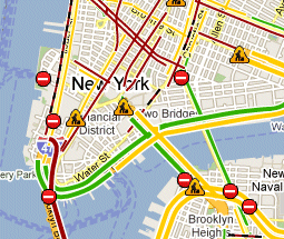
12/28/2009 01:34 | Can the traffic information be displayed on the Google map?
Thanks. |
|
Juerg
12/28/2009 13:55 | Ed,
we now have added the �Display Traffic Information� option the the Google Map Web Part.
Please re-download the updated Zip file, extract and then replace the DLL (followed by an �iisreset� command if you deployed the DLL to c:\windows\assembly�) |
|
Ilya
3/5/2010 12:27 | Good day. Very good web part, I think many people will benefit.
My server is using Russian locale, as the decimal point is ','. Options longitude / latitude are operate normally and the default map shows the necessary part. But when choosing an item from the list I get the following error:
Column 'Address' does not belong to list!
Available columns:
Attachments
LinkTitle
_x0413__x043e__x0440__x043e__x04
_x0410__x0434__x0440__x0435__x04
Column 'City' does not belong to list!
Available columns:
Attachments
LinkTitle
_x0413__x043e__x0440__x043e__x04
_x0410__x0434__x0440__x0435__x04
Any thoughts on this? Thank you for any answer! |
|
Gunther
4/14/2010 06:16 | I would like a "hybrid" of this part and the geomapper part. I would like to connect to a web part and display the locations for all list items in that web part, and have all of the bubble capability of the geomapper. |
|
Juerg
4/15/2010 15:27 | Gunther,
would you want to select a List item in the connected and then have the Web part show the corresponding bubble ? |
|
Gunther
4/16/2010 05:43 | It would be great to connect the map web part to another web part on a page, and have the map web part display each list item in the connected web part as the pin. In addition when you select a item in the list of the connected web part then have the corresponding map pin show the bubble information. It would be nice to be able to hover over the pins and have the bubble pop-up as well.
Here is an example of what I am wanting to do-
I have a web part page that displays the basic company information. It has a webpart displaying a filtered list from a "company sites" list that shows the sites for the company. I want to show these sites on the map, and have the behaviour described above. |
|
Juerg
4/16/2010 18:24 | Gunther, we think it's a good idea to add this feature to the Geo Mapper web part (which seems more suitable since it already is displaying all the items containend in the selected Sharepoint List). |
|
Gunther
4/17/2010 01:56 | That would be great. I will keep an eye out for the update.
Thanks |
|
luis reis
5/25/2010 20:22 | good work, but my map does not appear centered ( the red pin in the middle ). I must adjust manually to see the pin. I also cannot see the "interactive check". I have evaluation web part. thanks |
|
Juerg
5/26/2010 10:12 | Luis,
it looks like you are using a very old version of the web part since we've added the "Interactive Map" option about a year ago. |
|
Dan
6/21/2010 21:06 | It worked the first time I entered data from a row, but now it's just showing a blue square. Is there a way to debug the data being passed from the list to the Web Part? Thanks! |
|
Dan
6/21/2010 21:43 | Never mind - I got it to work again. |
|
Steve
7/17/2010 00:31 | I just downloaded the trial and installed it on our dev machine. I have it setup for Seattle, WA using Lat and Long but I cannot get the traffic overlay to work. Google maps has traffic information for Seattle too. Is this feature disabled on the trial? |
|
Steve
7/17/2010 00:48 | I just got the traffic overlay to work. It appeared that the interactive maps option needs to be checked. |
|
Radhika
8/7/2010 12:30 | Can it be used for any country other than US? |
|
Radhika
8/7/2010 12:50 | Ok, its working for me. But it would be nice if it had the bubble display as someone else mentioned. |
|
Juerg
8/9/2010 10:53 | Radhika,
we will add the bubble feature in the next release. |
|
Dan
8/13/2010 01:52 | The webpart does not render traffic for Paris, France. I tried other cities (Chicago, London) and it worked fine. Any ideas what the problem might be. I checked on Goolge maps and they do provide traffic coverage for Paris, France.
I would appreciate a prompt response, Thank you! |
|
Juerg
8/13/2010 10:36 | Dan,
unfortunately the traffic information for France is not available when accessed via the Google Maps API (enforced by the French map data provider albeit the traffic data is actually available when accessed via maps.google.com).
An alternative solution is to use our Google Earth Web Part in combination with a real-time KML traffic overlay provided by www.v-trafic.com |
|
Ameha
9/1/2010 23:43 | On the bubble window I want to display a link that points to a document in my document library. The link opens documents when I click it on the list, but it does not work on the bubble window. Any help is appreciated on this. Thanks |
|
Juerg
9/2/2010 11:31 | Amaha, are you actually referring to the Google Geo Mapper web part (see /apps/page.asp?Q=5775 ) ? |
|
Ameha
9/2/2010 15:51 | Yes, I am using the Google Geo Mapper web part. |
|
SP2010
9/23/2010 21:01 | How can I actually center the web part? It seems like the map is always aligned to the left?
I tried to put it within <div style="text-align: center;"> </div> but still no joy.
Any ideas? |
|
Juerg
9/24/2010 16:02 | SP2010,
we have now added the new "Center Map" option to allow the map to be horizontally centered within the web part area.
Please re-download the updated Zip file, extract and then replace the DLL (followed by an iisreset command if you placed the DLL in c:\windows\assembly) |
|
SP2010
9/27/2010 10:26 | Juerg, thanks for the update. I do see the center option, but unfortunately it doesn't seem to work when checked. Looking at the html, it seems like the left position is forcing this:
<div style="position: absolute; width: 100%; height: 100%; overflow: hidden; top: 0px; left: 0px;">
Any thoughts? |
|
Juerg
9/30/2010 17:48 | SP2010,
the "Center" option indeed did not work for SP2010. We have now fixed this and have updated the Zip file accordingly. |
|
Active
10/6/2010 11:31 | Hi Jureg,
I am getting the error below after connecting the webpart with List --
Google Gecoding Error: No corresponding geographic location could be found for the specified address, possibly because the address is relatively new, or because it may be incorrect
Please let me where can I get the gecoding api?
Thanks in advance |
|
Juerg
10/6/2010 17:34 | Active,
did you put the proper List field names into the web part's "Address" field (as described in the configuration instructions above) ?
Also, does your List item contain a valid address than can be resolved by Google Maps (it might contain a typo) ? |
|
Active
10/7/2010 11:34 | Thanks for the reply Juerg -- Yes, "Address" field is added to the List and the address resolves by Google map, still I am getting the same error.
|
|
Juerg
10/7/2010 13:48 | Active,
can you give an example of an address that does not work ?
Can you also indicate how you entered the List field(s) into the web part's "Address" field ? |
|
Active
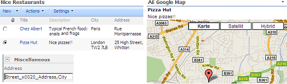
10/8/2010 12:52 | Hi Juerg, The webpart address field
- Title,Address
The List entries is
-- Title Address Pizza Hut 25 High Street, Whitton, London TW2 7LB
Please advice |
|
Juerg
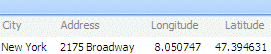
10/8/2010 16:11 | SP2010, see the example below (please note that for illustration purposes I added a column which consists of 2 words to the connection to show how to enter such a field by using _x0020_ as the blank character):
 |
|
John
1/31/2011 17:10 | I have sent 2 emails to your support team and haven't received any response. It's been more than a week. Help!!!!!!! |
|
John
1/31/2011 23:28 | I was using the wrong email address. Thanks for your help! |
|
Jeff
3/23/2011 22:19 | Is it possible to display one or more placemarks via a connected list similar to the KML feature. We have a sharepoint list of site locations and we would like to plot them all versus sending them one row at a time. Thanks! |
|
Jeff
3/23/2011 22:55 | Nevermind - just found the GeoMapper component! Thanks and great work. |
|
Randine Perry
11/1/2011 16:55 | I just purchase couple of webparts one been the google map web part, I've configured this to work with my sharepoint lists, and I get the following message:
Google Gecoding Error: No corresponding geographic location could be found for the specified address, possibly because the address is relatively new, or because it may be incorrect.
The address works fine in googlemap using postcode or latitude and longitude.
My platform is SharePoint 2007 enterprise edition,.
Need this resolve soon as possible as the site goes live Thursday.
|
|
Juerg
11/1/2011 18:49 | Randine,
do you use the web part stand-alone, ie. did you enter a street address into the web part�s �Address� setting ?
If yes, what exactly did you enter
|
|
Maver
11/10/2011 02:19 | Hello, I have the webpart. Is there a way i can use it to display on a SSL page? |
|
heriberto
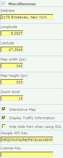
3/9/2012 18:56 | how i get google API key ? i enter ti the url http://code.google.com/intl/en/apis/maps/signup.html
and i dont'n know get it. |
|
Juerg
3/9/2012 19:00 | Heriberto,
can you quickly check the web part�s version number by opening the web part�s tool pane and looking it up at the top ?
If it�s V1.1.10 or lower, then please re-download the updated Zip file from our web site at /apps/page.asp?Q=5754, extract and then replace the DLL, followed by an �iisreset� command if you placed the DLL in c:\windows\assembly.
We recently released the new version 1.2 of the web part which now does not require the Google API key anymore. |
|
Mario
4/2/2012 17:41 | Hello Juerg,
Someone else asked for the SSL support.
Any news on this?
Kind regards,
Mario |
|
Juerg
4/2/2012 18:17 | Mario and Maver,
we actually added SSL support with version 1.2.0 (you can check the web part�s version number by opening the web part�s tool pane and looking it up at the top). |
|
MartinG
6/26/2012 21:37 | I've been trying to make the Google Map and Mapper Webparts work in our Office 365 environment but I cannot establish a connection - the List Webpart claims that the Google Map Webparts can't receive the data. We've done the Solution install but had to follow the O365 'Upload Solution' path to do that as we can't run lower level code. Any ideas what we have missed? |
|
Juerg
6/27/2012 12:06 | Martin,
Office365/Sharepoint Online unfortunately disables web part connections due to the technical design of the Sharepoint "sandbox".
We hope that Microsoft will lift off this restriction in the next version of Sharepoint Online. |
|
Nick
6/12/2013 20:16 | I'm trying to Geocode a fairly large list (40,000+ lines) and it appears the process times out. Is there a maximum records or a timeout setting that can be managed? Thanks! |
|
SPInquiry
6/16/2013 08:36 | Hello, was wondering if you planned on allowing percentages to modify width and height of the map webpart alongside the current pixel option. Thanks! |
|
Juerg
6/17/2013 12:05 | SPInquiry,
the Google Map web part now interprets a "Map Width" value equal to or less than "100" as a precentage.
Please re-download the updated Zip file, extract the WSP file and then update the web part solution. |
|
MV123
8/20/2013 19:01 | Is there a way to display directions from one point on a list to another without redirecting to google maps? |
|
Simon
1/21/2014 07:10 | Unable to send data from a list to the webpart on Office 365?
O365 does allow connections now - but it doesn't show in the list of options for my list Connections?
Help! |
|
Juerg
1/21/2014 13:11 | Simon,
the Microsoft Office365 �sandbox� environment unfortunately does not support web part connections for non Microsoft out-of-the box web parts. |
|
Sander
3/28/2014 15:59 | I'm using this webpart 1.2.9 on a https sp2010, but I receive a warning about mixed http and https content when I activate this WP, despite the fact I read since 1.2.0 SSL is supported.
Any ideas to fix this?
In page source I see a url :<script src='http://maps-api-ssl.google.com/maps/api/js?v=3&sensor;=false' ... |
|
Juerg
3/29/2014 14:38 | Sander,
for some reason the web part cannot sense that your site is using SSL
Anyway, you can force the web part to use the HTTPS: protocol as follows:
You will need to add the below line to the �appSettings� section of your Sharpeoint application�s web.config file (typically located at c:\Inetpub\wwwroot\wss\VirtualDirectories\80)
<appSettings>
.
.
<add key="AESSL" value="1" />
</appSettings> |
|
Sander Pluijmert
3/31/2014 14:48 | Thank you for your quick reply.
Your solution fixed my problem :) |
|
Dexi
5/1/2014 14:13 | I have 2 questions regarding your very handsome plugin before buying it.
1st : Is there a way to select multiple addresses from the list and have all of the selected coordinates appear at the same time on the map? I will have a huge list and quick lookup on our different offices would be great
2nd : Is there a way to add a URL dynamic link into the plugin? Like you have the red dot pinpoint, I want to be able to click that red dot and redirect it to a PDF. Thanks in advance!
|
|
Juerg
5/1/2014 16:18 | Samuel,
the Google Map web part only shows a single location pin at a time.
You thus might check out the Geo Mapper web part (see /apps/page.asp?Q=5775 ) which is able to show multiple locations.
It also allows to display information about the location in an info bubble (shown when either clicking on a pin or hovering over the pin) and also place an URL in the info bubble. |
|
Andrew
6/14/2014 19:15 | Is there a way to load the address information via query string or SQL query web part? We have all our address information stored in SQL server. |
|
Juerg
6/16/2014 11:53 | Andrew,
the Google Map web part also either accepts the address information to be passed in via one or more URL parameters or via a web part connection. You also can configure the SQL Query Viewer web part to send the selected address to a Google Map web part placed on the same page or directly open the map as a popup window. |
|
Andrew
6/16/2014 16:46 | Juerg,
Thanks for your response. Where can I find out information on the URL parameters? |
|
Juerg
6/16/2014 17:06 | Andrew,
you can enter the URL parameter names into the web part�s �Address� setting, enclosed in curly braces.
Example:
{Street Address}, {City}, {Country} |
|
Kelly
10/15/2014 05:51 | Another great Webpart Juerg.
I am using SP 2013 so my list view by default has the "Find an Item" at the top of the list - which is used. If an item is searched, it filters and if the line is highlighted (the item is ticked), the map doesn't change. If I click on the double-ended arrow next to the item, the map changes but then the list resets itself back to show all of the items, not just the search result. How can I get around that? |
|
Juerg
10/16/2014 19:07 | Kelly,
there is unfortunately no fix to correct this behavior which is inherent to Sharpeoint 2013 (eg. selecting an item via a web part connection resets the search filter). |
|
nooshin
7/14/2015 13:23 | I have used the web part in automatically way as you have been indicated. But when I added it to the SharePoint site, Beyond of its title, wrote "currently Disabled". I have mention that I am using SharePoint 2010. What could be the problem?
|
|
Juerg
7/14/2015 15:15 | nooshin,
please check the "GeoCoder" web part�s �Geocoding enabled� checkbox to activate the geocoding. |
|
Giuseppe Di Giulio
6/24/2016 17:29 | In Office 365 the webpart because I cannot specify a Google API key, the field
is missing in the webpart configuration section. |
|
Juerg
6/30/2016 21:41 | Giuseppe,
you do not need to pass the Google �Premier� key with every map request (Google removed this restriction about 2 years ago). |
|
Groove
8/1/2016 19:14 | The web part is not displaying in interactive mode when I embed scripting to eliminate jquery flicker as the page loads.
The embedded script is
<script>
document.write('<style type="text/css">body{display:none}</style>');
jQuery(function($) {
$('body').css('display','block');
});
</script>
as specified at the following link http://monc.se/kitchen/152/avoiding-flickering-in-jquery
Is there more appropriate scripting to use?
Thanks. |
|
Juerg
8/12/2016 18:58 | James,
please note that the Google Map �interactive� mode uses JavaScript provided by Google which seems to interfere with your jQuery script.
It might be worthwile to try the below variant:
<script>
document.write('<style type="text/css">body{visiblity:hidden}</style>');
jQuery(function($) {
$('body').css('visibility','visible');
});
</script> |
|
Leanne
12/11/2018 01:40 | How does your web part work now that Google Maps have stopped "Keyless Usage" and you must have an API key with billing enabled? Does it still work since the Google API changes in July 2018? |
|
Juerg
12/11/2018 09:39 | Leanne,
Google indeed recently changed its policy and now requires you to enable billing when using the Google Maps platform API:
https://cloud.google.com/maps-platform/pricing/
Please note that your account will most probably not be charged since Google gives you a $200 monthly credit which covers up to 28,500 page views per month.
We thus recently updated the web part to allow you to enter your Google API key.
Please re-download the web part and the update the web part solution.
A good overview on how to get your API key (to be entered into the web part�s �Google API Key� setting) and to enable billing can be found here:
https://elfsight.com/blog/2018/06/how-to-get-google-maps-api-key-guide/
|
|
Mohammad Naghavi
11/25/2019 15:13 | Hello,
It seems that the web part is s showing the following error for internet explorer:
"you are using a browser that is not supported by the Google Maps Javascript API, Consider changing your browser."
Please help. I really need this.
Thanks and Regards,
Mohammad
|
|
Juerg
11/25/2019 15:31 | Mohammad,
we have now fixed this issue, so the web part will work with IE 11 and older IE versions, too.
Please re-download the web part and then update the web part solution. |
|
Mohammad
11/27/2019 21:47 | Hello,
After 2 days of troubleshooting on the issue, it is still showing the error.
I deployed an updated version of the new solution to the development and QA but still showing the error.
Please help to solve this issue.
Thanks and Regards,
Mohammad |
|
Juerg
12/6/2019 17:07 | Mohammad,
we have now applied another fix, so the web part will work with IE 11 and older IE versions, too.
Please re-download the web part nd then update the web part solution. |
|
Horst
8/26/2020 07:01 | Is there a possibility to translate/replace the "Get Directions" link ?
Thanks for your help |
|
Juerg
8/26/2020 16:48 | Horst,
we have now added the new �directions� option (to be added to the web part�s �Options� setting) as illustrated below:
directions=Your custom text here
Please re-download the web part and then update the web part solution. |


 No place like Amrein! Best Webparts, great prices, and even better customer service!


 Web Part Installation Instructions
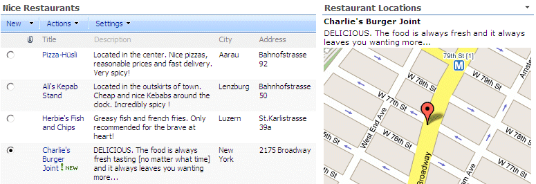

 Post a Comment